Reliable · Thermal · Predictive
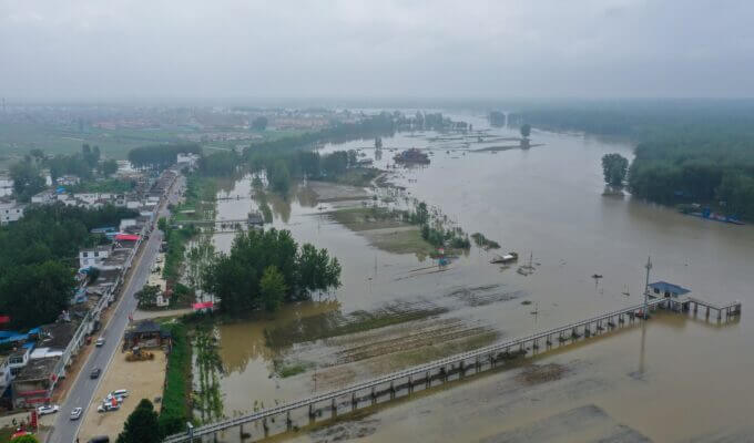
Infrastructure & transportation
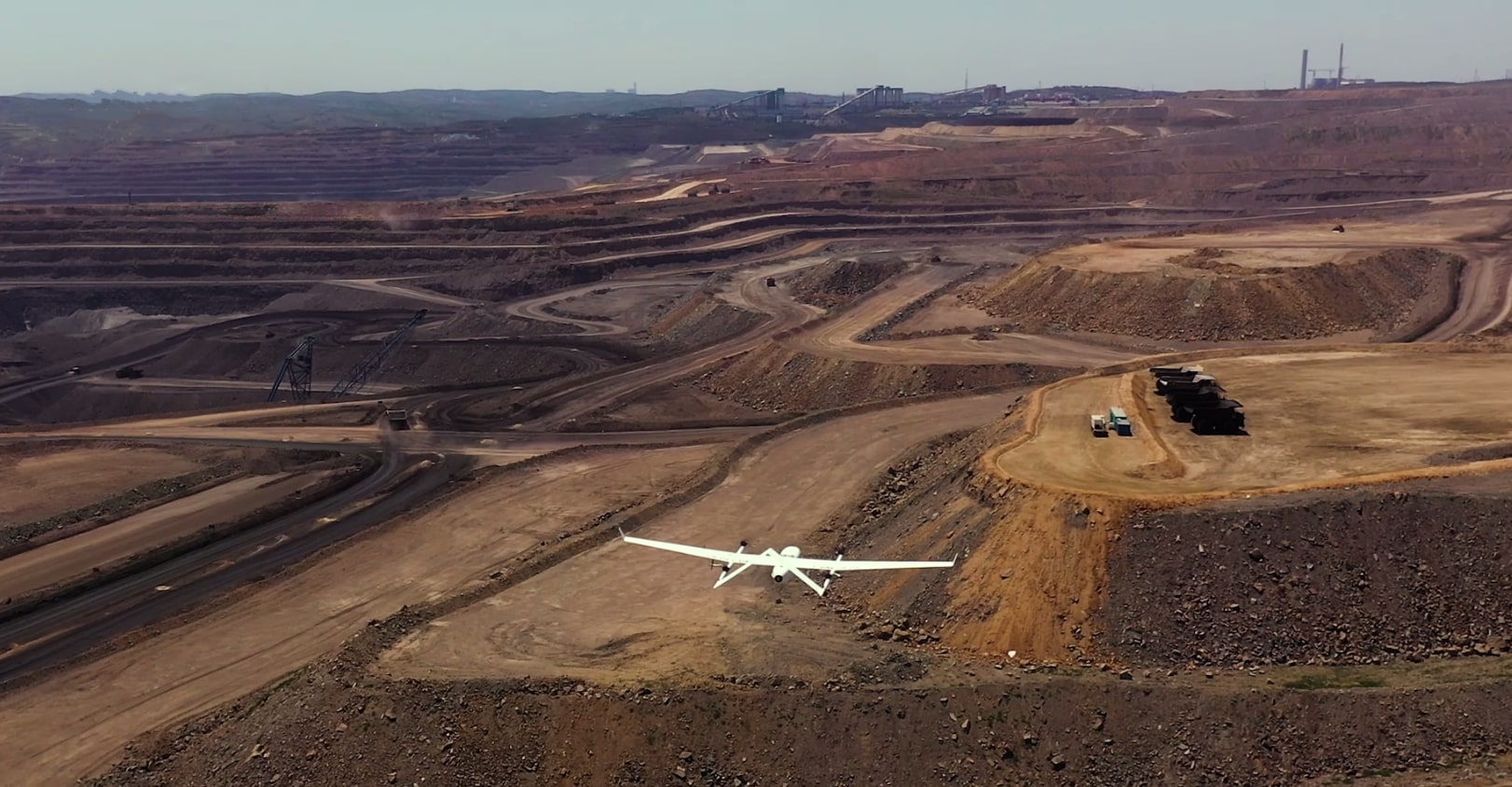
Corridors, lines, and critical assets with VTOL inspection, SAR, and change detection — NV5 tech-enabled engineering pattern.
View infrastructure →Cusco AOI · demo run
DAI-ATLAS · THE FUTURE IS MEASURABLE
Sicuani → Cusco → Quillabamba · five live nodes.
Peru Program: from signature in Lima to sovereign desk in 90 days. PeruSAT, CW-15, and D-Sentinel — territorial future already running in Cusco.
One pipeline observes every signal in parallel — satellite, field, sensors, global context — and delivers an auditable probability your team can trust.
ES/EN desk · Lima UTC−5 · Derteano.
DAI-ATLAS fuses the best of leading platforms — with Peruvian sovereignty, not brochure copy.
Contractual and Atlas pipeline metrics — every number traceable to OEM, CONIDA, or GDELT.
90 days
Peru Program · signature to live desk
Desk → Baseline → Full Field · weeks 1–12
5,200 m
VTOL operational ceiling in the Andes
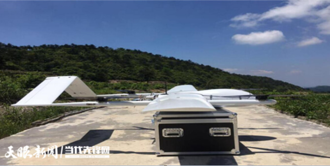
CW-15 / CW-25E · JOUAV OEM spec
47
GDELT sources verified in D-Sentinel
GDELT Project · open intelligence desk
48 h
ORBIT BRIDGE · PeruSAT to field
PeruSAT-1 (CONIDA) → RTK confirmation
NV5 pattern: infrastructure, energy, natural resources, and GeoAI software — video, data, and field in one tenant.
Corridors, lines, and critical assets with VTOL inspection, SAR, and change detection — NV5 tech-enabled engineering pattern.
View infrastructure →Thermal, LiDAR, and orbit over SEPIER and high-altitude networks — operational continuity before failure.
View energy →Tailings, basins, and concessions with satellite + field fusion — auditable traceability for technical boards.
View resources →From pilot to production: geospatial analytics, AI agents, and sovereign API — enterprise scale without silos.
Explore platform →Integrated geospatial platform
Like Esri and Google Geospatial Analytics, we integrate data through geographic context — satellite, sensors, analytics, and AI on DAI-ATLAS, deployable sovereignly for Peru and LATAM.
PeruSAT, Sentinel, SAR, and ORBIT BRIDGE windows over your AOI.
CW VTOL, SENAMHI sensors, and mesh telemetry with auditable custody.
Indices, L0–L4 scores, change detection, and native AI agents.
Alerts, exportable brief, and API — from pixel to technical board.
Six institutional routes with real field imagery — the same AOI running in the interactive Cusco demo.
MapLibre at −13.52° — five parallel nodes over concessions, slopes, and Abancay–Quillabamba VTOL access.
Open map →CW-15 LiDAR, thermal, and PeruSAT NDVI on structures with L3→L4 traceability and ORBIT BRIDGE brief.
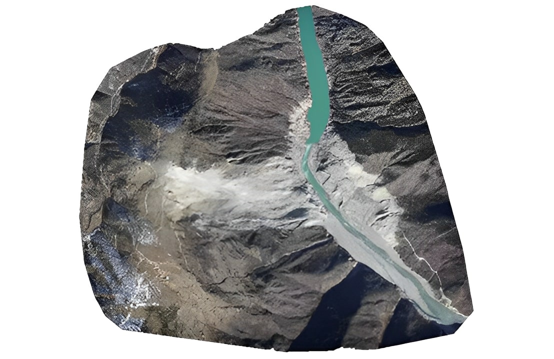
View mining →SENAMHI + mesh sensors crossed with NDVI — irrigation, downstream tailings, and early warnings.
View water →Thermal inspection, invasive vegetation, and faults on high-altitude transmission assets.
View lines →Precipitation, early warnings, and GDELT ingest on coastal and highland events.
View emergencies →Desk → Baseline → Full Field — signature to sovereign desk EN/ES with operator certification.
Quote program →PeruSAT, Sentinel, CW-15, and D-Sentinel in one tenant — imagery, field truth, and DAI tools without silos.
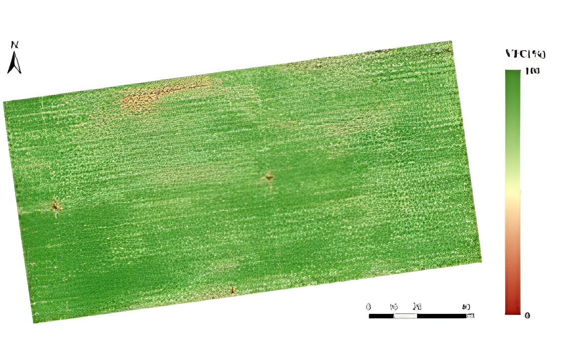
NDVI, cover change, and ORBIT windows on concessions.
Open Atlas →Verified headlines as the pipeline temporal seed.
View sources →Open temporal stacks over concession, basin, or institutional corridor.
View agriculture →Satellite, VTOL, terrestrial sensors, and GDELT context run on the same AOI at once — no sequential silos or scattered tabs.
Product demo
5 parallel nodes · Cusco AOI −13.52°
Cusco · PeruSAT-1 window · −13.52°
NDVI, cover change, and ORBIT BRIDGE windows on concessions and critical infrastructure.
RTK orthophoto, LiDAR, and thermal when the program includes OEM layer — CW-15 / CW-25E.
SENAMHI, USGS, and mesh gateways feed the Atlas bus with auditable timestamps.
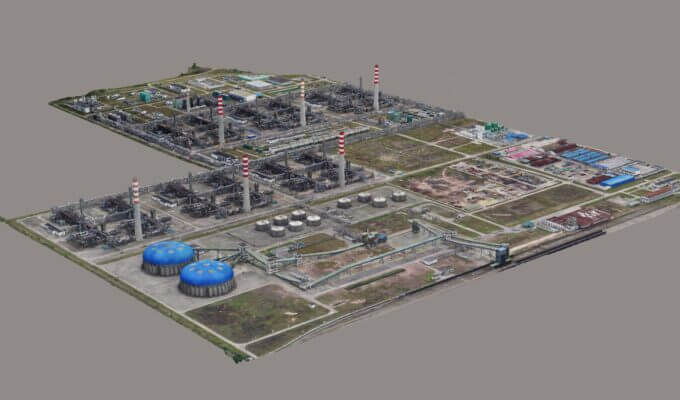
Orthophoto, point clouds, and thermal alerts on slopes and dams in one tenant.
View mining →Line inspection, corridors, and assets with SAR + optical layers for technical review.
View infrastructure →Domains, orgs, IPs, and vendors tied to the AOI enrich the pipeline — digital footprint joins fusion, not a separate export.
Product demo
Digital graph · MINEM concession
Click a graph node or row — digital traceability on the AOI.
WHOIS, DNS, org→ASN, and breaches in the same flow as field data.
Link mining concession to supply chain before awarding or responding to incidents.
Discovered nodes feed fusion scores with custody line — not loose PDFs.
Org→infrastructure and municipal vendor relationships in shareable layers.
View smart city →Suppliers, logistics, and exposed domains crossed with crop vigor and climate.
View agriculture →The fusion engine correlates GDELT, satellite, field, sensors, and digital graph — unified score plus ORBIT BRIDGE brief within 48 h.
Product demo
Multi-source correlation
Toggle sources on or off — Atlas probability recalculates instantly.
71%
Fused Atlas probability
5/5 active sourcesOne territorial percentage with confidence interval — tailings, infrastructure, escalation.
Contradictions across nodes lower score; converging signals raise it.
Who confirms in field, what to inspect, which assets to deploy — institutional export.
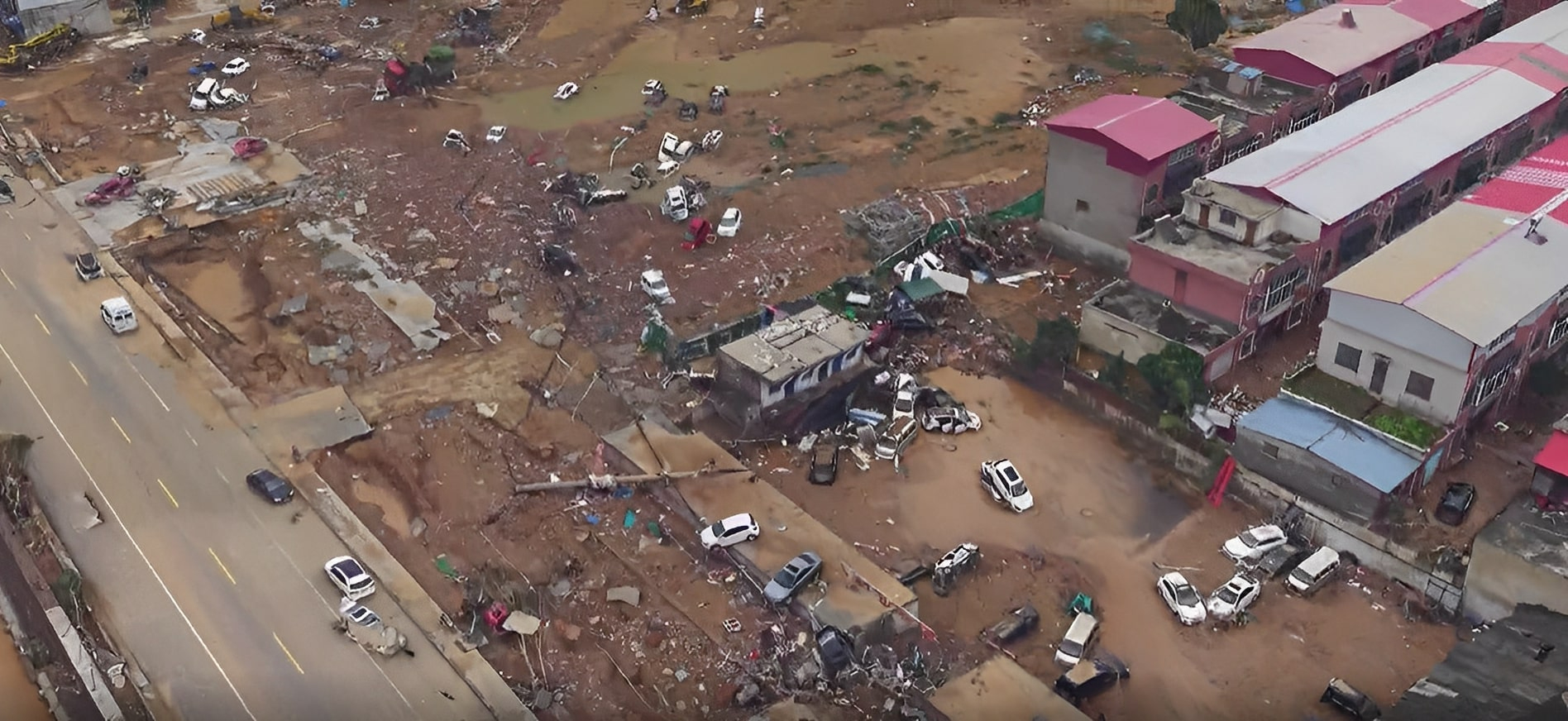
Flood, seismic, or thermal anomaly — probability plus shareable action list.
View emergencies →Basins, dams, and precipitation crossed with NDVI and near-real-time sensors.
View water →Contractual weeks 1–12 timeline — not a generic remote sensing course.
Integration workshop, institutional AOI, and custody policy — ES/EN desk in Lima UTC−5.
Control network, first CW-15 sortie, and PeruSAT/Sentinel ingest over your concession or corridor.
D-Sentinel cron, Atlas L4 score, and API handoff — certified operators in tenant.
From raw ingest to fused probability with exportable ORBIT BRIDGE brief — traceability at every step.
NASA Earth Observation Data Basics pattern — traceability at every Atlas pipeline step.
Raw telemetry, uncorrected satellite scenes, GDELT feeds.
Atmosphere, geometry, and registration over institutional AOI.
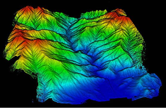
NDVI, RTK orthophoto, LiDAR point clouds ready for GIS.
Cover change, tailings risk, multi-node correlation.
Fused score + exportable ORBIT BRIDGE brief.
Visual clarity, traceability, and field action — not market tickers or loose layers.
GDELT, satellite, drones, sensors, and digital OSINT converge in one pipeline — not scattered spreadsheets.
The visual language operations directors expect — light background, explicit legends.
PeruSAT, SENAMHI, concessions, and field prioritized — provenance citations on every output.
Simulated activity for visitors; D-Sentinel cron and sidecars when the tenant is in production.
Peru Program and ORBIT BRIDGE metrics — mining, power grid, and high-Andean hydrology.
5,200 m
CW series ceiling validated on slopes, tailings dams, and SEPIER lines — field where satellite resolution is not enough.
View CW platforms →90 days
Three institutional tiers — OEM hardware, DAI-ATLAS, field teams, and EN/ES training included.
Quote Peru Program →47
Verified headlines as the pipeline temporal seed — no market ticker noise.
View DAI solutions →48 h
CONIDA trigger, VTOL sortie, or mesh relay — continuity between orbit and auditable field truth.
Explore DAI stack →NV5 pattern: tech-enabled engineering, actionable data, and field deployment.
100+
B2G geospatial engineering across mining, utilities, and infrastructure.
48h
From Atlas probability to VTOL sortie, satellite window, or mesh relay.
5
GDELT, satellite, VTOL, sensors, and digital graph — one unified score.
90 d
Desk → Baseline → Full Field — signature to sovereign EN/ES tenant with certified operators.
Institutional voices by sector in real Peru scenarios — not named client endorsements.
ORBIT
ORBIT · LINK · VISION
LEO window over your AOI — before risk hits the ground.
Satellite telemetry, computer vision, and field relay — sovereign continuity without fantasy marketing.
Believe in the future above your AOI.
GeoAI, digital twins, and institutional deployment — at Peru Program pace.
How to move from isolated pilots to Atlas L4 pipeline with traceability, 24 h SLA, and sovereign tenant — Peru Program lessons.
Request demo →Multi-node fusion, ORBIT BRIDGE brief, and API handoff — the same enterprise digital twin pattern, adapted to institutional AOI.
View stack →MapLibre + agents + D-Sentinel cron architecture — NASA Earthdata-style EO fundamentals at Peruvian pace.
View solutions →Atlas fuses heterogeneous signals into probability with an action brief — not just stacked uncorrelated layers.
Guided demo, 90-day pilot, or full tenant deploy — same pipeline, different sidecar depth.
Reference UX patterns: Esri · Google Geospatial Analytics · NASA Earthdata · SpaceX · NV5 · Anduril · JOUAV